Exploring the World with Geospatial Data Science: Applications, Challenges, and Opportunities
This article provides an overview of geospatial data science, including its applications in environmental monitoring, disaster response, urban planning, and transportation planning. It also discusses the challenges facing the field, such as data quality, integration, and privacy concerns, and highlights opportunities for future growth and development.
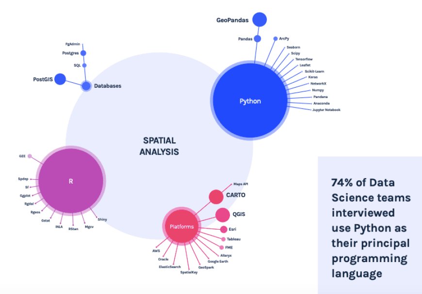
Geospatial data science is a rapidly growing field that has gained significant attention in recent years. It combines the principles of data science with the understanding of geospatial data, which is data that is referenced to a specific location on the earth's surface. Geospatial data science has a wide range of applications, including environmental monitoring, disaster response, urban planning, and transportation planning, among others.
In this article, we will explore the fundamental concepts of geospatial data science, including what geospatial data is, how it is collected and processed, and the various tools and techniques used to analyze and visualize spatial data.
What is Geospatial Data?
Geospatial data, also known as spatial data, is data that is referenced to a specific location on the earth's surface. It can take various forms, including GPS coordinates, satellite imagery, maps, and other sources. Geospatial data can be used to create visual representations of physical and cultural features on the earth's surface, such as roads, buildings, water bodies, and land use patterns.
Geospatial data is often used in conjunction with other types of data, such as demographic data, weather data, and economic data, to gain insights and make informed decisions. By combining spatial data with other data sources, researchers and analysts can identify patterns and trends that might not be apparent in either data source alone.
How is Geospatial Data Collected and Processed?
Geospatial data can be collected in several ways, including remote sensing, GPS tracking, and surveys. Remote sensing involves the use of satellites, aircraft, or drones to collect data about the earth's surface. This can include data about land use patterns, vegetation, water bodies, and other physical and cultural features. GPS tracking involves the use of GPS devices to track the movement of people or objects on the earth's surface. Surveys involve the collection of data from people through interviews, questionnaires, or other means.
Once geospatial data is collected, it must be processed and analyzed to make it useful. This can involve several steps, including data cleaning, data integration, and data visualization. Data cleaning involves identifying and correcting errors or inconsistencies in the data. Data integration involves combining data from different sources to create a complete picture of the phenomenon being studied. Data visualization involves creating visual representations of the data, such as maps or graphs, to make it easier to interpret.
Tools and Techniques Used in Geospatial Data Science
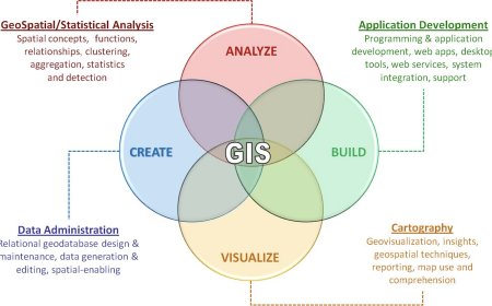
There are several tools and techniques used in geospatial data science, including geographic information systems (GIS), remote sensing, spatial analysis, and machine learning.
Geographic Information Systems (GIS)
GIS is a computer-based tool used to create, store, and analyze geospatial data. It allows users to create maps, analyze spatial data, and make informed decisions based on the results. GIS can be used in a variety of applications, including urban planning, natural resource management, and emergency response.
Remote Sensing
Remote sensing involves the use of satellites, aircraft, or drones to collect data about the earth's surface. It can be used to gather information about land use patterns, vegetation, water bodies, and other physical and cultural features. Remote sensing can be used in a variety of applications, including environmental monitoring, disaster response, and natural resource management.
Spatial Analysis
Spatial analysis involves analyzing geospatial data to identify patterns and relationships. It can be used to answer questions about spatial relationships, such as proximity, distance, and direction. Spatial analysis can be used in a variety of applications, including urban planning, transportation planning, and natural resource management.
Machine Learning
Machine learning involves the use of algorithms and statistical models to analyze data and make predictions. It can be used in geospatial data science to analyze and interpret large datasets. Machine learning algorithms can be used to identify patterns and relationships in geospatial data, such as predicting the likelihood of a wildfire based on weather conditions and land use patterns.
Future Directions in Geospatial Data Science
The field of geospatial data science is constantly evolving, with new techniques and tools being developed regularly. Here are some of the future directions of geospatial data science:
- Big Data and Cloud Computing
Geospatial data is becoming increasingly large and complex, which presents challenges in terms of data storage, processing, and analysis. The use of cloud computing can help address these challenges by providing a scalable and cost-effective solution for storing and processing large amounts of data.
- Artificial Intelligence and Machine Learning
The use of artificial intelligence (AI) and machine learning (ML) in geospatial data science is expected to grow rapidly in the coming years. AI and ML can be used to analyze and interpret large amounts of data, identify patterns and relationships, and make predictions.
- 3D Visualization
The use of 3D visualization in geospatial data science is expected to become more widespread. 3D visualization can provide a more realistic and immersive experience, allowing users to better understand and interact with geospatial data.
- Internet of Things (IoT)
The Internet of Things (IoT) is a network of devices that are connected and can communicate with each other. IoT devices can collect geospatial data in real-time, providing valuable insights into environmental conditions, traffic patterns, and other phenomena.
- Augmented Reality (AR)
Augmented reality (AR) is a technology that overlays digital information on top of the real world. AR can be used to provide real-time information about the environment, such as the location of nearby amenities or the status of public transportation.
Applications of Geospatial Data Science
Geospatial data science has a wide range of applications across several industries, including environmental monitoring, disaster response, urban planning, and transportation planning. Here are some of the applications of geospatial data science:
- Environmental Monitoring
Geospatial data science can be used to monitor environmental conditions, such as air and water quality, and identify areas that require remediation. It can also be used to monitor the impact of climate change on the environment and wildlife habitats.
- Disaster Response
Geospatial data science can be used to support disaster response efforts, such as identifying areas that are at risk of flooding or wildfires. It can also be used to track the location of emergency responders and monitor the progress of relief efforts.
- Urban Planning
Geospatial data science can be used to support urban planning efforts, such as identifying areas that require infrastructure improvements or determining the optimal location for a new development. It can also be used to monitor urban growth and development over time.
- Transportation Planning
Geospatial data science can be used to support transportation planning efforts, such as identifying traffic patterns and optimizing transportation routes. It can also be used to monitor the condition of transportation infrastructure, such as roads and bridges.
- Agriculture
Geospatial data science can be used to support agricultural activities, such as monitoring crop yields and identifying areas that require irrigation or fertilization. It can also be used to monitor the impact of climate change on agriculture and wildlife habitats.
Challenges in Geospatial Data Science
Geospatial data science faces several challenges, including data quality, data integration, and privacy concerns. Addressing these challenges is essential to ensure that geospatial data science is used ethically and responsibly.
- Data Quality
Geospatial data can be collected in several ways, including remote sensing, GPS tracking, and surveys. However, the quality of the data can vary depending on the method of collection, the accuracy of the equipment used, and the expertise of the individuals collecting the data. Poor data quality can lead to inaccurate analyses and decisions.
- Data Integration
Geospatial data is often collected from multiple sources, which can lead to challenges in data integration. Different sources may use different formats, scales, or projection systems, making it difficult to combine the data into a single dataset. Data integration requires careful attention to ensure that the data is consistent, complete, and accurate.
- Privacy Concerns
Geospatial data can contain sensitive information, such as the location of individuals or sensitive infrastructure. Privacy concerns must be addressed to ensure that the data is used ethically and responsibly. Techniques such as de-identification and aggregation can be used to protect privacy, but care must be taken to ensure that the data is still useful for analysis.
- Technical Challenges
Geospatial data science requires a high level of technical expertise, including knowledge of GIS, remote sensing, spatial analysis, and machine learning. These skills are in high demand, and there is a shortage of qualified individuals to fill these roles. In addition, the technology and tools used in geospatial data science are constantly evolving, requiring individuals to continuously update their skills and knowledge.
- Ethical and Legal Considerations
Geospatial data science raises several ethical and legal considerations, such as data ownership, data sharing, and data use. Data must be collected and used in an ethical and responsible manner, taking into consideration the privacy and legal implications of the data.
Conclusion
Geospatial data science is an essential tool for understanding and interacting with the world around us. It has a wide range of applications across several industries, including environmental monitoring, disaster response, urban planning, transportation planning, and agriculture. Geospatial data can be collected in several ways, including remote sensing, GPS tracking, and surveys. Once collected, it must be processed and analyzed to make it useful, using tools and techniques such as GIS, remote sensing, spatial analysis, and machine learning. While geospatial data science faces several challenges, including data quality, data integration, and privacy concerns, addressing these challenges will help ensure that geospatial data science is used ethically and responsibly.
What's Your Reaction?


