GIS Applications & Uses – How GIS Technology Is Changing the World
Discover how GIS technology is transforming the world with numerous applications and uses in various industries. Learn about the benefits of GIS, real-world examples, and how to get started with GIS technology. Explore the ways GIS technology is changing the world for the better.
GIS Applications & Uses – How GIS Technology Is Changing the World
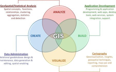
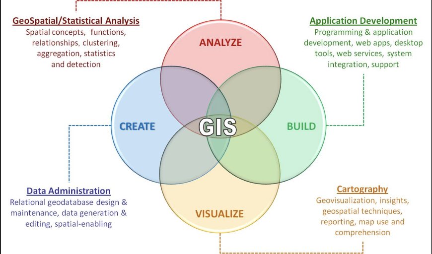
Geographic Information Systems (GIS) have transformed the way we see the world. This technology allows us to collect, store, analyze, and display data related to geography and location. GIS technology has numerous applications and uses across various industries, including environmental management, urban planning, disaster management, and transportation.
GIS is Changing the World
GIS technology has been around for decades, but its use and popularity have grown significantly in recent years. This is largely due to advancements in computer technology and the increasing availability of spatial data. GIS technology is changing the world by providing valuable insights and solutions to complex problems.
Environmental Management
GIS is a powerful tool for environmental management. With GIS technology, environmental scientists and managers can collect, analyze, and visualize data related to environmental conditions. This data can be used to identify areas of concern, track changes over time, and evaluate the effectiveness of environmental management strategies.
One of the most significant uses of GIS in environmental management is for monitoring and tracking natural disasters. With the ability to collect data in real-time, GIS can help identify areas of concern during natural disasters such as hurricanes, floods, and wildfires. This data can be used to quickly deploy resources and respond to emergencies.
Urban Planning
GIS technology is changing the way urban planners design cities. By using GIS, urban planners can collect and analyze data related to population, transportation, housing, and infrastructure. This data can be used to make informed decisions about land use, zoning, and transportation planning.
One of the most significant applications of GIS in urban planning is for transportation planning. With the ability to analyze traffic patterns and congestion, GIS can be used to design more efficient and sustainable transportation systems. This includes designing public transit routes, bike lanes, and pedestrian walkways.
Disaster Management
GIS technology has revolutionized disaster management. With GIS, emergency managers can quickly identify areas of concern during natural disasters, such as hurricanes, floods, and wildfires. This data can be used to quickly deploy resources and respond to emergencies.
GIS can also be used for disaster preparedness. By collecting and analyzing data related to potential hazards, such as earthquakes or tsunamis, emergency managers can develop evacuation plans and prepare for emergencies before they happen.
Transportation
GIS technology has numerous applications in transportation. With the ability to analyze traffic patterns and congestion, GIS can be used to design more efficient and sustainable transportation systems. This includes designing public transit routes, bike lanes, and pedestrian walkways.
GIS can also be used for logistics and supply chain management. By analyzing transportation routes and shipping patterns, GIS can be used to optimize supply chain management, reduce costs, and improve efficiency.
Future of GIS Technology
The future of GIS technology is exciting, and we can expect to see even more innovative applications and uses in the years to come. Some of the emerging trends in GIS technology include the use of artificial intelligence (AI), machine learning, and big data.
AI and machine learning can be used to analyze large volumes of data and identify patterns and trends that might not be immediately apparent. This technology can be used to make more accurate predictions and inform decision-making in various industries, including urban planning, transportation, and disaster management.
Big data is another emerging trend in GIS technology. As the volume of data available continues to grow, GIS can be used to store and analyze this data to provide valuable insights and solutions to complex problems.
Challenges
While GIS technology has many benefits, it also presents some challenges.GIS data is only useful if it is accurate and up-to-date. Collecting and maintaining quality data can be challenging, particularly in remote or underdeveloped areas.
Another challenge is the cost of GIS technology. While GIS technology has become more affordable in recent years, it can still be expensive for smaller organizations or those in developing countries.
As GIS technology continues to collect and store large volumes of data, it is essential to ensure that this data is secure and protected from cyber threats.
Real-World Examples of GIS Applications
1.Natural Disaster Management: During the 2011 Fukushima disaster in Japan, GIS technology played a critical role in disaster management. Emergency responders used GIS to collect and analyze data related to the disaster, including radiation levels, wind direction, and evacuation routes. This data was used to inform decisions about evacuations and resource deployment.
2.Urban Planning: In the city of Barcelona, Spain, GIS technology is used for urban planning. City planners use GIS to collect and analyze data related to population, transportation, and infrastructure. This data is used to inform decisions about land use, zoning, and transportation planning.
3.Environmental Management: In the Great Barrier Reef, Australia, GIS technology is used for environmental management. Scientists use GIS to collect and analyze data related to water quality, sea temperature, and marine life. This data is used to inform decisions about conservation efforts and policy-making.
4.Transportation: In the city of Amsterdam, Netherlands, GIS technology is used for transportation planning. City planners use GIS to collect and analyze data related to traffic patterns and congestion. This data is used to inform decisions about public transit routes, bike lanes, and pedestrian walkways.
5.Agriculture: In the United States, GIS technology is used for precision agriculture. Farmers use GIS to collect and analyze data related to soil conditions, weather patterns, and crop yields. This data is used to inform decisions about planting, irrigation, and fertilization.
Benefits of GIS Technology
1.Increased Efficiency: GIS technology can help organizations and individuals make more informed decisions, leading to increased efficiency and productivity.
2.Cost Savings: By providing valuable insights and solutions to complex problems, GIS technology can help organizations save money by optimizing operations and reducing costs.
3.Improved Communication: GIS technology can help improve communication between different stakeholders by providing a shared understanding of data related to geography and location.
4.Better Decision-Making: By providing valuable insights and solutions to complex problems, GIS technology can help individuals and organizations make better decisions.
5.Environmental Sustainability: By helping organizations make more informed decisions about environmental management, GIS technology can help promote environmental sustainability.
Conclusion
GIS technology is changing the world. With its ability to collect, store, analyze, and display data related to geography and location, GIS is transforming various industries, including environmental management, urban planning, disaster management, and transportation. GIS provides valuable insights and solutions to complex problems, making it an essential tool for decision-makers across various industries. As GIS technology continues to advance, we can expect to see even more innovative applications and uses in the future.
GIS technology is transforming the world, providing valuable insights and solutions to complex problems in various industries. From natural disaster management to urban planning and agriculture, GIS has numerous applications and uses. While there are challenges associated with GIS technology, the benefits of GIS technology far outweigh the challenges. If you are interested in learning more about GIS technology, start by learning the basics, choosing a GIS software, collecting data, analyzing data, and sharing your results. With the right tools and knowledge, you can use GIS technology to make more informed decisions and create a better world.
What's Your Reaction?


