Exploring New Frontiers in Virtual Reality and Geospatial Mapping
Discover the exciting intersection of virtual reality and geospatial mapping. Explore the transformative potential, from enhancing spatial visualization to collaborative decision-making. Unlock new frontiers in technology and knowledge.
Introduction
In today's rapidly advancing technological landscape, the convergence of virtual reality (VR) and geospatial mapping has opened up exciting new possibilities. This article delves into the fascinating realm where these two innovative technologies intersect, offering a comprehensive exploration of the ways they can shape our future. With a focus on bridging the digital and physical worlds, this article aims to shed light on the transformative power of virtual reality in the context of geospatial mapping.
The Rise of Virtual Reality
Understanding the Fundamentals of VR
Virtual reality, commonly referred to as VR, is a simulated experience that can be similar to or completely different from the real world. By employing cutting-edge technology, VR immerses users in a computer-generated environment, stimulating their senses and enabling them to interact with a virtual realm. This technology has evolved rapidly in recent years, offering a range of applications across various industries.
Unleashing Boundless Potential
The potential of virtual reality extends far beyond gaming and entertainment. Industries such as education, healthcare, architecture, and tourism are leveraging VR to revolutionize their respective fields. In education, for example, VR can transport students to historical events or distant places, enhancing their learning experiences. Meanwhile, healthcare professionals utilize VR to train medical students, simulate surgeries, and even treat patients with conditions such as phobias or post-traumatic stress disorder (PTSD).
VR's Role in Geospatial Mapping
Geospatial mapping involves the collection, analysis, and interpretation of geospatial data to create accurate representations of physical spaces. By incorporating virtual reality into the geospatial mapping process, we can gain new perspectives and unlock valuable insights. VR technology allows us to visualize geospatial data in a three-dimensional environment, enabling better decision-making, analysis, and planning.
The Intersection of VR and Geospatial Mapping
Enhancing Spatial Visualization
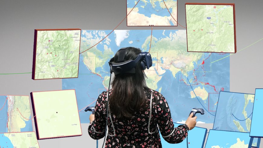
One of the key benefits of merging VR and geospatial mapping is the ability to enhance spatial visualization. Traditional mapping methods often rely on two-dimensional representations, which can limit our understanding of complex spatial relationships. By leveraging virtual reality, geospatial data can be visualized in an immersive and interactive manner. This empowers users to explore and analyze landscapes, buildings, and urban environments with unprecedented depth and clarity.
Real-Time Data Integration
Another powerful aspect of combining VR and geospatial mapping lies in the integration of real-time data. By connecting geospatial mapping systems with live data feeds, such as traffic information or weather updates, users can experience dynamic and up-to-date virtual environments. This real-time integration opens up new possibilities for urban planning, disaster response, and navigation systems.
Collaborative Decision-Making
Virtual reality facilitates collaborative decision-making by allowing multiple users to interact within a shared virtual space. Geospatial mapping, combined with VR technology, enables teams to visualize and discuss complex spatial scenarios, leading to more informed and efficient decision-making processes. Whether it's urban planning, architecture, or emergency management, the ability to collaborate in a virtual environment enhances communication and fosters innovative solutions.
Simulating Future Scenarios
VR-driven geospatial mapping also empowers us to simulate and assess future scenarios. By integrating predictive models and simulations into virtual environments, we can explore the potential impact of urban development, climate change, or infrastructure projects. These simulations provide valuable insights into the consequences of different decisions, aiding policymakers, city planners, and stakeholders in making informed choices for a sustainable future.
Future Prospects and Implications
As the convergence of virtual reality and geospatial mapping continues to advance, the potential implications are vast and diverse. Here are some key areas where this synergy can shape the future:
Urban Planning and Smart Cities
Virtual reality and geospatial mapping have the potential to revolutionize urban planning and the creation of smart cities. By visualizing proposed infrastructural changes, analyzing transportation networks, and simulating urban growth, planners can optimize resource allocation, enhance sustainability, and improve quality of life for residents.
Environmental Conservation
The fusion of VR and geospatial mapping can be instrumental in environmental conservation efforts. By creating immersive experiences that highlight ecological challenges, such as deforestation or climate change, VR can raise awareness and drive action towards sustainable practices. Additionally, geospatial mapping aids in monitoring biodiversity, tracking wildlife populations, and identifying conservation priorities.
Disaster Preparedness and Response
Virtual reality, combined with geospatial mapping, offers valuable tools for disaster preparedness and response. By simulating potential disaster scenarios, emergency management teams can develop effective evacuation plans, assess vulnerability, and train first responders. This integration enhances situational awareness and promotes resilience in the face of natural or man-made disasters.
Conclusion
The convergence of virtual reality and geospatial mapping represents a pivotal juncture in technological innovation. This article has explored the myriad ways in which these two fields intersect and influence each other, from enhancing spatial visualization to enabling collaborative decision-making. As VR and geospatial mapping continue to evolve, their potential to revolutionize industries and transform our understanding of the physical world is truly remarkable. By embracing this synergy and pushing the boundaries of what is possible, we can embark on an exciting journey into new frontiers of knowledge and exploration.
What's Your Reaction?


