The Role of Geospatial Data in Wildlife Conservation Efforts
Discover the crucial role of geospatial data in wildlife conservation efforts. Explore how mapping habitats, tracking wildlife movements, and assessing environmental changes contribute to effective conservation strategies. Learn how collaboration and data sharing enhance conservation planning. Harness the power of geospatial data to protect our planet's biodiversity.

Introduction
In the ever-evolving field of wildlife conservation, geospatial data has emerged as a powerful tool for understanding and protecting our planet's biodiversity. With the increasing threats to wildlife habitats and ecosystems, leveraging geospatial data has become crucial in designing effective conservation strategies. This article explores the significant role of geospatial data in wildlife conservation efforts and how it contributes to preserving our natural heritage.
Understanding Geospatial Data
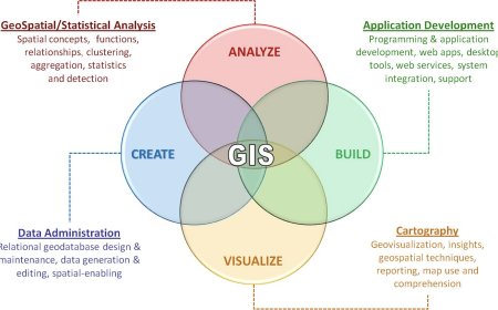
Geospatial data refers to information that is tied to specific geographic locations on the Earth's surface. It encompasses various data types, including satellite imagery, aerial photographs, digital maps, and geographical information systems (GIS). Geospatial data allows conservationists to analyze and visualize complex ecological patterns and processes, enabling them to make informed decisions and take targeted actions.
Mapping Wildlife Habitats
One of the primary applications of geospatial data in wildlife conservation is mapping and monitoring wildlife habitats. By analyzing satellite imagery and aerial photographs, conservationists can identify critical habitats and determine their suitability for different species. Geospatial data provides valuable insights into the distribution of wildlife populations, helping conservationists understand migration patterns, nesting areas, and feeding grounds.
Using advanced GIS techniques, conservationists can create accurate and up-to-date maps that highlight areas of high biodiversity significance. These maps serve as a foundation for establishing protected areas, wildlife corridors, and other conservation initiatives. Geospatial data allows conservationists to prioritize their efforts and allocate resources effectively, ensuring the preservation of crucial habitats.
Tracking Wildlife Movements
Geospatial data plays a vital role in tracking the movements of wildlife species, especially those that have extensive home ranges or migrate over long distances. With the help of GPS collars, satellite transmitters, and other tracking technologies, researchers can collect precise location data for individual animals. This information is then integrated with geospatial data to visualize and analyze the movement patterns of wildlife.
By understanding how animals utilize their habitats and navigate the landscape, conservationists can identify potential threats and implement measures to mitigate them. Geospatial data allows for the identification of critical corridors and connectivity pathways that are essential for maintaining genetic diversity and enabling species to adapt to changing environmental conditions.
Assessing Environmental Changes
Geospatial data enables conservationists to assess and monitor environmental changes that impact wildlife populations. By comparing historical and current data, researchers can identify areas experiencing habitat loss, fragmentation, or degradation. These insights are crucial for understanding the drivers of change and formulating effective conservation strategies.
Satellite imagery and remote sensing techniques provide valuable information on vegetation cover, land use changes, and other environmental factors that influence wildlife habitats. Conservationists can use this data to detect early warning signs of ecosystem decline and take proactive measures to protect vulnerable species.
Enhancing Conservation Planning
Geospatial data plays a critical role in conservation planning by providing a comprehensive understanding of ecological systems and their dynamics. By integrating multiple layers of data, such as topography, climate, and land cover, conservationists can develop sophisticated models that predict species distributions, identify ecological hotspots, and assess the effectiveness of conservation interventions.
With the aid of geospatial data, conservation planning becomes more evidence-based and adaptive. It allows conservationists to identify priority areas for habitat restoration, species reintroduction, and conservation education. By leveraging geospatial data, conservation organizations can optimize their resources and make informed decisions that yield long-term positive impacts on wildlife populations.
Collaboration and Data Sharing
Geospatial data promotes collaboration among conservation organizations, researchers, and governmental agencies. By sharing data and insights, stakeholders can work together to address common challenges and achieve conservation goals more effectively. Geospatial data platforms and online mapping tools facilitate data sharing, enabling a wider community to access and analyze critical information.
Collaborative efforts enhance the accuracy and comprehensiveness of geospatial data, leading to better-informed conservation strategies. Through partnerships and knowledge exchange, conservationists can build a collective understanding of ecological processes and implement collaborative initiatives that transcend geographic boundaries.
The Future of Geospatial Data in Wildlife Conservation
As technology continues to advance, the role of geospatial data in wildlife conservation will only become more critical. Emerging technologies, such as drones and remote sensing satellites, offer unprecedented opportunities for data collection and analysis. These advancements enable conservationists to gather high-resolution imagery, detect subtle changes in the environment, and monitor wildlife populations with greater accuracy.
Furthermore, the integration of geospatial data with other innovative fields, such as artificial intelligence and machine learning, holds immense potential for advancing wildlife conservation efforts. These technologies can analyze vast amounts of data, identify patterns, and make predictions that aid in proactive conservation planning. For example, machine learning algorithms can process geospatial data to predict the occurrence of wildlife conflicts or the spread of invasive species, allowing for early intervention and prevention.
Another exciting development is the use of geospatial data in citizen science initiatives. By engaging the public in data collection through mobile applications and participatory mapping, conservation organizations can harness the power of crowdsourcing. This approach not only increases data coverage but also fosters public awareness and engagement in conservation efforts.
Overcoming Challenges and Ethical Considerations
While geospatial data offers immense benefits for wildlife conservation, there are also challenges and ethical considerations that need to be addressed. One significant challenge is the accessibility and availability of high-quality geospatial data, particularly in developing regions. Efforts must be made to bridge this data gap and ensure that conservationists worldwide have access to the necessary resources to make informed decisions.
Ethical considerations regarding data privacy and the impact on local communities also arise when collecting and utilizing geospatial data. It is crucial for conservation organizations to collaborate with local stakeholders, respect indigenous knowledge, and obtain consent when conducting research or using data that may have cultural or traditional significance.
Furthermore, the accuracy and reliability of geospatial data must be continuously validated and updated. Ongoing monitoring and quality control processes should be in place to ensure that decisions based on geospatial data are accurate and effective.
Conclusion
Geospatial data has transformed the way we approach wildlife conservation. By providing crucial insights into habitats, movements, and environmental changes, it empowers conservationists to make informed decisions and implement targeted strategies. The integration of geospatial data with emerging technologies and collaborative efforts will drive further advancements in the field, strengthening our ability to protect and conserve the Earth's rich biodiversity.
As we move forward, it is essential to prioritize the accessibility, accuracy, and ethical use of geospatial data. By leveraging its full potential and addressing the challenges it presents, we can work together to safeguard wildlife populations, preserve ecosystems, and create a sustainable future for both wildlife and humanity.
What's Your Reaction?


